Basic 6 · Our World and Our People · Map Making and Landmarks
Natural Landmarks of Ghana on the Map
In this topic you will identify Ghana's natural landmarks, locate them on a map and explain them as wonders of creation.
By the end of these notes you should be able to:
- Name important natural landmarks in Ghana
- Locate landmarks on a map using a key
- Explain why landmarks should be protected
What you already know
- Attributes of God seen in creation
Copy everything that has a blue line on its left into your notebook. The other parts are for reading.
- Strand
- Nature Of God
- Sub-strand
- Map Making and Landmarks
- Indicator
- B6.1.1.1.1 – Describe the attributes of God
Introduction
Ghana has beautiful natural wonders: mountains, waterfalls, lakes and forests. These landmarks show the beauty of creation and help us find our way on maps.
1. What Is a Landmark?
Landmark: An easily recognised feature of a place that helps people find their way.
Landmarks can be natural (mountains, rivers, waterfalls) or human-made (castles, dams, bridges). Natural landmarks are part of God's creation.
2. Natural Landmarks of Ghana
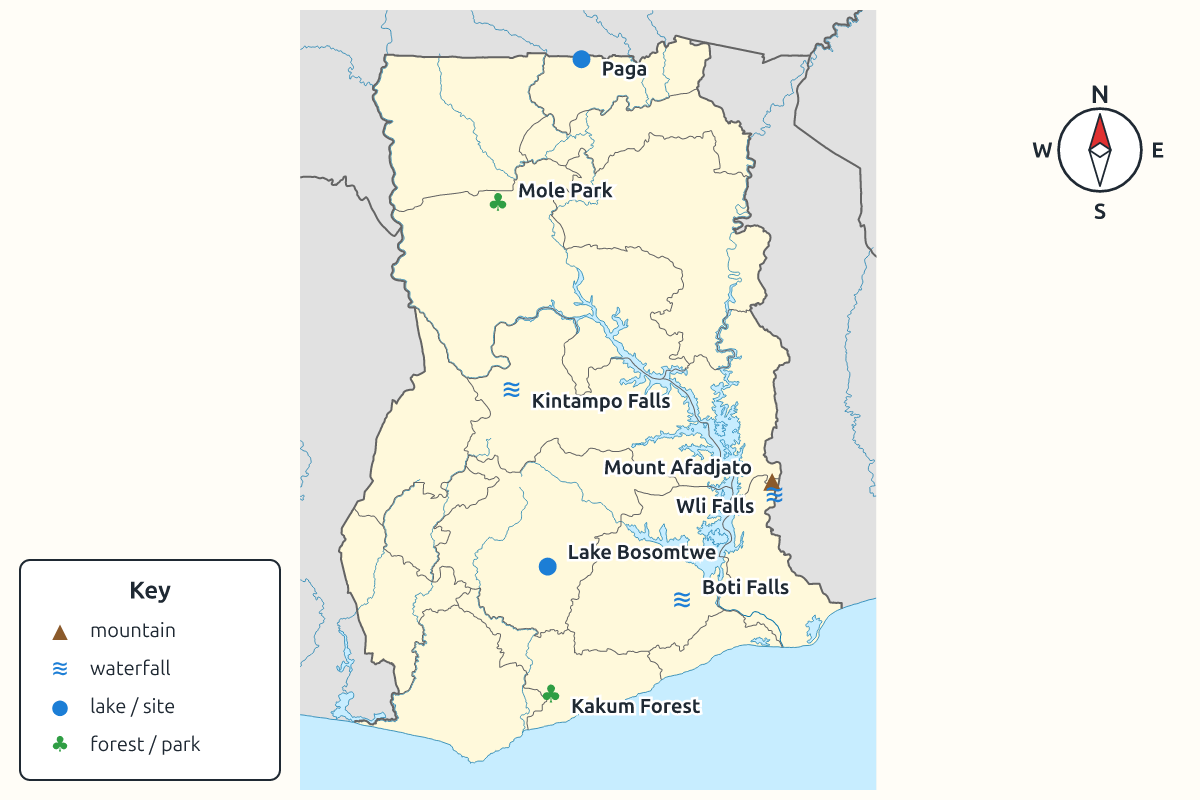
| Landmark | Region | Description |
|---|---|---|
| Mount Afadjato | Volta | one of the highest points in Ghana (about 885 m) |
| Wli Waterfalls | Volta | one of the highest waterfalls in West Africa |
| Lake Bosomtwe | Ashanti | a natural lake formed in a meteorite crater |
| Kintampo Waterfalls | Bono East | waterfalls on the Pumpum River |
| Boti Falls | Eastern | twin waterfalls ("male and female") |
| Kakum Forest | Central | rainforest with a canopy walkway |
| Mole National Park | Savannah | savannah with elephants and antelopes |
| Paga Crocodile Pond | Upper East | sacred pond with friendly crocodiles |
| Volta River | several regions | Ghana's largest river system |
3. Using a Map
A map is a drawing of a place as seen from above. To read a map, use the title, the key (legend) that explains symbols, the compass that shows directions (north, south, east, west) and the scale that shows distances.
| Feature | Common symbol |
|---|---|
| mountain | ▲ |
| river | blue line |
| lake | blue shape |
| waterfall | blue line with a short bar across it |
| forest | green tree shapes |
| town | dot or circle |
4. Protecting Landmarks
Natural landmarks attract tourists, provide water and habitats, and are part of our heritage. They are threatened by deforestation, mining, littering and hunting. We protect them by obeying park rules, not littering, supporting conservation and respecting local taboos that protect sacred places.
Tourism to these places also creates jobs for tour guides, drivers, hotel workers and craftspeople, so protecting landmarks helps the local economy as well as nature.
New words
- landmark
- An easily recognised feature of a place.
- map
- A drawing of an area seen from above.
- key (legend)
- The part of a map that explains symbols.
- compass
- A tool or symbol that shows directions.
- crater
- A bowl-shaped hole in the ground.
- heritage
- Valuable things passed down from the past.
Summary
- Landmarks help us recognise places; natural ones are part of creation.
- Ghana's landmarks include Afadjato, Wli Falls, Lake Bosomtwe and Kakum.
- Maps use a title, key, compass and scale.
- Landmarks must be protected for tourism, nature and heritage.
Class activity: Landmark Map
- Draw a large map of Ghana on manila paper.
- Mark at least six natural landmarks with symbols.
- Add a key, compass and title.
You need: Local leaves, Flowers, Stones, Printed photographs of Ghanaian landscapes
Exercises
Answer in your exercise book first, then check your answers.
1. Lake Bosomtwe is in which region?
- A. Ashanti
- B. Volta
- C. Central
- D. Northern
Show answer
Answer: AshantiNear Kumasi.2. The part of a map that explains symbols is the…
- A. key
- B. scale
- C. title
- D. border
Show answer
Answer: keyAlso called the legend.3. Wli Waterfalls is in…
- A. the Volta Region
- B. the Western Region
- C. the Upper West Region
- D. the Central Region
Show answer
Answer: the Volta RegionNear Hohoe.4. Kakum Forest has a canopy walkway.
- A. True
- B. False
Show answer
Answer: TrueIn the Central Region.5. A castle is a natural landmark.
- A. True
- B. False
Show answer
Answer: FalseIt is human-made.6. A tool that shows directions is a ______.
Show answer
Answer: compassNorth, south, east, west.7. Name four natural landmarks in Ghana and their regions.
Show answer
Answer: Mount Afadjato (Volta), Lake Bosomtwe (Ashanti), Kakum Forest (Central), Mole (Savannah).Any four.8. Why should natural landmarks be protected?
Show answer
Answer: They attract tourists, provide habitats and water, and are part of our heritage and God's creation.Several reasons.
Homework
- Find out about a natural landmark near your home and draw it.